

Hydrographic surveys measures and map underwater physical features. These surveys estimate underwater depths, to enable vessels and marine equipment to traverse water bodies safely, and identify the location of pipes, sunken planes, and ships. Additionally, coastal engineers use survey data to inform coastal models.
There are different types of hydrographic surveys and different levels and type of information which can be used complementarily or stand-alone depending on the purpose. Two types of hydrographic surveys frequently used by CEAC are:
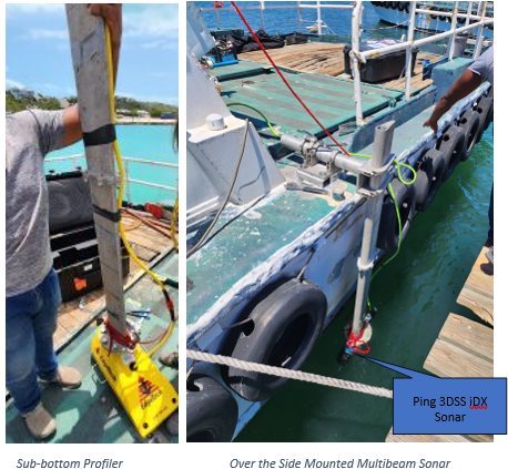
- Bathymetric Surveys to measure the depth of underwater terrains. The technology CEAC used for bathymetric surveys include single-beam echo sounding, multibeam echo sounding, and side-scan sonar. Bathymetric data is complemented by LiDAR surveys as the topographic features put the bathymetric data into perspective.
- Sub-bottom Profilers to generate a cross-sectional view if the structures beneath the seabed and identify underground voids and utilities. In Engineering, data from this survey is useful to guide the design of sub-sea floor marine infrastructures and in conducting hazard and risk assessments. Sub-bottom profiling (SBP) uses low-frequency sound waves to image sediment and rock layers beneath the seafloor. SBP emits pulses that travel through water and reflect off layers with different densities. By calculating the depth of various sediment or rock layers, we use SBP to derive material thickness.
CEAC recently surveyed 20 sq km of seas within the Caribbean to determine the suitability for vessels to traverse through an approach channel and utilize a proposed anchorage area. This project required data from Multibeam surveys and Sub-bottom Profiling to map the seabed characteristics in the proposed berthing area.
